Friday, June 28, 2013

South Lake Tahoe, CA (Mile 1095)

We pulled into Lake Tahoe, CA yesterday afternoon. We were lucky enough to catch a ride from a father and son that have a family cabin in the area that gave us a little tour. I know we've been saying everything is gorgeous, but it's quite spectacular here and I bet it's even more scenic with snow. I mean the Lake looks like a Caribbean Beach! It's easy to see why there is so much tourist activity here. Looking out onto the lake there are tons of boats, SUP boarders (Stand Up Paddling), and other aquatic activities.

The plan had been to take a "zero day", but we had some unexpected bad weather earlier this week and we retreated to town with our tails between our legs. Evidently, remnants of a tropical storm all the way from Asia made it to California. For us that meant cold temperatures, probably in the low 40s during the day, gusty winds, and rain for 2 days straight. Seeing how it's only rained for a total of 4 hours prior to this storm, we have only been carrying rain jackets. Without the proper equipment after 10 miles of hiking each of us were thoroughly soaked and freezing. We dropped down from around 9,500' to the block long town of Markleeville, CA. Despite only a sentence or two about the town in our guidebook, it turned out to be one of the best stops so far. Everyone in the town, minus the visitor center lady, were extremely friendly and went out of their way to help us. The proprietor at the Marklee Toll Station Motel even washed our laundry and gave us fresh hot cinnamon rolls!

The halfway point is just over 200 miles away! We calculated out that we need to average around 20 miles a day to make it Canada by October 1st. After this little taste of bad weather I definitely have a little more urgency to make it to Washington by late August! Plus we a have a wedding to attend in early October and family to visit!

Devil's Post-pile National Monument. These basalt columns form when hot lava cools very rapidly.
Iceman cooking my birthday dinner (I cook most nights).
Thousand Islands Lakes, Yosemite National Park.
The last snow covered pass in the High Sierras!
Granite domes located around Tuolumne Meadows.
Tuolumne Falls and extremely annoying tread--it was like a really poorly constructed cobbled road.
Looking downstream around Glen Allen camp.
One of the few times there was a mandatory get your feet wet ford.
Iceman demonstrating the "Alpine Shower" technique.

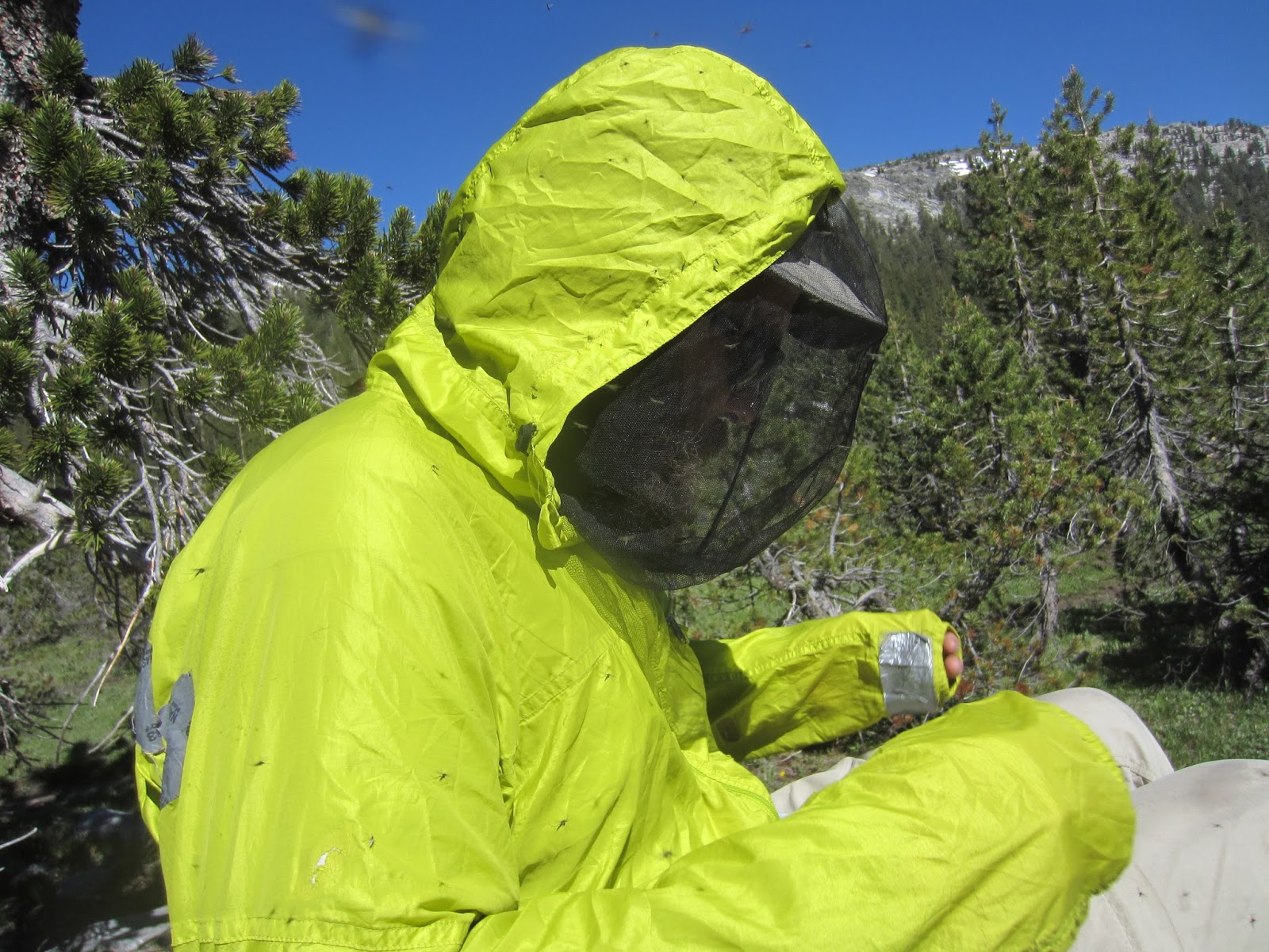
The mosquitoes were MISERABLE! We tried to take a break and ended up having to walk over 10 miles before we could stop.
Dorothy Lake located at the northern boarder of Yosemite National Park.
1,000th mile!!!
Amazing ridge walk just south of Sonora Pass, CA.
One of the longest stretches of snow we've seen so far, but still easily traversed without an ice axe.
We got a ride to Northern Kennedy Meadows Resort, but had trouble getting back up to the pass. Ended up taking 3 hitches and road walking for 45 minutes.
But we were rewarded with a trail party when we got back! Good beer and company!
Beautiful sunset and moonrise all at the same time!
We highly recommend the Sonora Pass area for hiking and we heard there's great backcountry skiing there as well.
Amazing granite formations with tons of chimneys!
A storm is a brewing....
You'll notice 3 of the same tents and we all had the same sleeping pads as well!
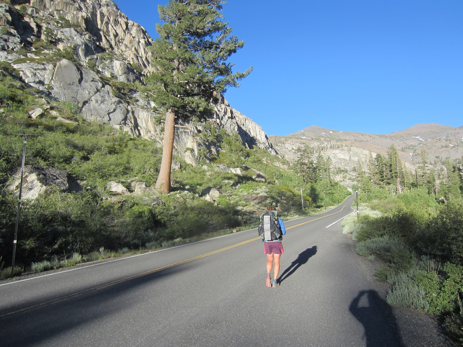
Hitching out of Markleville, CA.
We made it back to the pass and quickly jumped in the tent, because it was STILL raining!
The most amazing trail magic, which included eggs with chili and the ladies got brie on the side.
Interesting volcanic formations.


First good view of Lake Tahoe, CA.

Saturday, June 15, 2013

Mammoth Lakes, CA (Mile 906.6)

We arrived in Mammoth Lakes, CA yesterday afternoon to take a couple of days off to celebrate making it through the High Sierras and to celebrate my birthday.  The Sierras were everything we hoped for and more. The "more" included rugged trail, snow covered trail, new critters, lots of  big accents and descents, and unbelievable views. If you have any time to check out this part of the country, I would say that this area is a must see. Better yet if you don't have time, I say you should make some time! We traveled through Sequoia National Park, Kings Canyon National Park, John Muir Wilderness Area, and we will be entering Yosemite National Park in a few days. Plus Death Valley is not too far away either. It's amazing how much is packed together!

Not a lot of new news, but we did have a couple of minor gear issues this last stretch. Iceman had a marmot nibble on his trekking poles when we were hanging out at Guitar Lake, just below Mount Whitney, and a few days later some small rodent chewed up his hydration bite valve in the middle of the night. And unfortunately I slipped during a ford across a stream and lost my sunglasses. But with a little improvisation, such as using our mosquito head-nets to block some of the light on snow crossings, we made it out just fine.

There are a lot of pictures, so that's it for now! I hope everyone is having a good spring/early summer!

Best break spot on the trail, hands-down!
The terrain is getting more precipitous.
Hiking towards Cottonwood pass.
First alpine lake we swam in. It was close to 11,500 ft.
Hiking towards Crabtree Meadows, where you leave the PCT to head up Mount Whitney.
There are lots of creek/stream crossings in the Sierras. During a normal snow year you have to ford them, but this was an extremely low snow year and we could rock-hop 95% of them.
Timberline Lake with Mount Whitney hiding behind the ridge directly behind us.
People were fishing in the lake with a fishing pole, but within  minutes of arriving I caught some with my hands! 

We spent 7 hours hanging out with a big group by Guitar Lake (11,500 ft) where PCT hikers start their Whitney hike.
Action shot while hiking the immaculate trail going up to Whitney.
Looking down the opposite side of the ridge (looking east) just below Whitney summit. The flat desert floor is the Owens Valley where Lone Pine is located and the LA aqueduct runs.
First snow!
Summit of Mount Whitney at 14,505 ft, which is the highest point in the contiguous US.
Hiking down. The lake on the right is just above where we camped.
You definitely had to watch your step, because the trail dropped off really quickly.
The amount of work that went into this trail is amazing. The John Muir Trial finishes here, so I imagine that crew has put a lot of time in.
How many Yellow-Bellied Marmots can you count?
I had to catch one more on my way out -- I couldn't help myself! (Golden Trout) 
Bighorn Plateau was amazing! 
Marmots were running around and the clouds were amazing!
Pika! These are considered an indicator species for climate change. 

The trees here are called Foxtail Pines and can live over 2,000 years. Sequoia National Park has some of the oldest trees. Climatologist use them to study past climatic shifts due to their long lifespans and the hardiness of the deadwood.
Hiking towards our first real pass, Forester Pass.
You can see how the valley was craved by glaciers (it has more of an"U" shape the a  "V").
Look at those switchbacks! A lot of the trails were built in the early 1930s.
Super steep on the right and it's hard to see in the picture, but Grand Entrance (a fellow thru hiker) is standing just above my head on another set of switchbacks.
The only snow on the south side. In a normal year this would be a very serious crossing  requiring an ice ax and crampons.
We did it! Forester Pass is the highest point on the PCT at 13,153 ft.
The snow was a little soft on the other side. Iceman postholed up to his waist!
Looking north.
Best alpine lake swim so far! For 11,500' the water was actually "warm".
The endangered Yellow-Legged Mountain Frog. They were all over the place.
Granite galore!
We camped just south of this lake.
We had to hike the Bullfrog Lake and Onion Valley trails (15 extra miles and over Kearsarge Pass) out in order to resupply, but the lakes and views were amazing.
Kearsarge Pinnacles in the background.
We met a very fast hiker named "Hacksaw" who averages 30 miles a day. He was nice enough to slow down and hike with us for a while.
I don't know if Tumbleweed was as excited about being in Lone Pine as I was....
Great spring water and break spot!
Glen Pass was also really steep. (see all the switchbacks!)
Almost to the top.
Probably the worst mosquitoes we've had so far. You can't see them in the photo, but there were thousands! 
One of the few bridges and the only suspension bridge we've crossed so far.
Taking a break at Pinchot Pass! (~12,000 ft)
One of my favorite campsites. You can see Iceman blowing up his Neoair sleeping pad on the left.
Best dinner spot ever!
I'm imitating a bear to demonstrate the quality of our bear hang (an improvised PCT bear hang method).
Hiking out the next morning. 
Looking down from close to the top of Mather Pass (~12,000 ft).

The clouds in the background were an indicator that something was heading our way!
This rock provided a little shelter, but it was still cold. We just got rain, but others higher up had sleet, hail, lightning and snow!
Only bear scat we've seen.
The clouds lifted for a little bit on the way to Muir Pass.
Dinner time!
Muir Pass (~12,000 ft) is up on the right. There was fresh snow the night before, so Iceman was breaking trail and doing an excellent job navigating on snow.
Muir Hut and the pass.
So beautiful and we had it to ourselves!
Such a nice break!
The alpine lakes are so clean and clear (Wanda Lake at 11,600 ft).
Heading down Seldon pass, which was one of the easier passes.
Can you see the cloud-bow?
Lakes, lakes, and more lakes.
Evolution Creek was only a knee high ford for us. In a normal year it can be one of the most dangerous fords on the entire trail.
Looking down valley.
2 years ago a huge wind storm came through and knocked down thousands of trees near Red's Meadow. We were told there were sustained wind speeds recorded over 150 mph!
Silver Pass and the last pass before Mammoth Lakes!
A tricky stream crossing, but we both made it with dry feet.
Huge Aspens lined the trail in this section.
Small stream crossing below a beautiful waterfall.
Improvised sunglasses...
This little guy held this pose for a while, so long in fact I was a little worried for his health. 
Mile 900!
More carnage from the wind storm. It was amazing how many large trees had been toppled roots and all.
This was a major burn from 1992 and the area had barely recovered. Make sure you put out your fires!
The cottage my parents treated us to for my birthday! Thank you Mom and Dad! Love you!!